
Skiing the Whiteface Toll Road
After two cancelled trips this winter I was finally able to get down to the Adirondacks to pay a visit to my old friends the High Peaks. My husband Glenn hadn't been down to the Lake Placid area since pre-Covid, so he was extra excited to cross the border again and be back in our old playground. Looking at my winter peak-bagging 'to-do' list, I had Whiteface and Esther Mountains still to complete. The winter season seems to allow a variety of creative ways to bag summits and Whiteface and Esther seems to present multitude of pathways and methods to get there. As it turned out our plan A didn't end up working out and we resorted to a new one altogether!
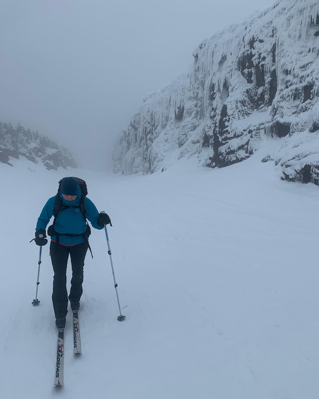
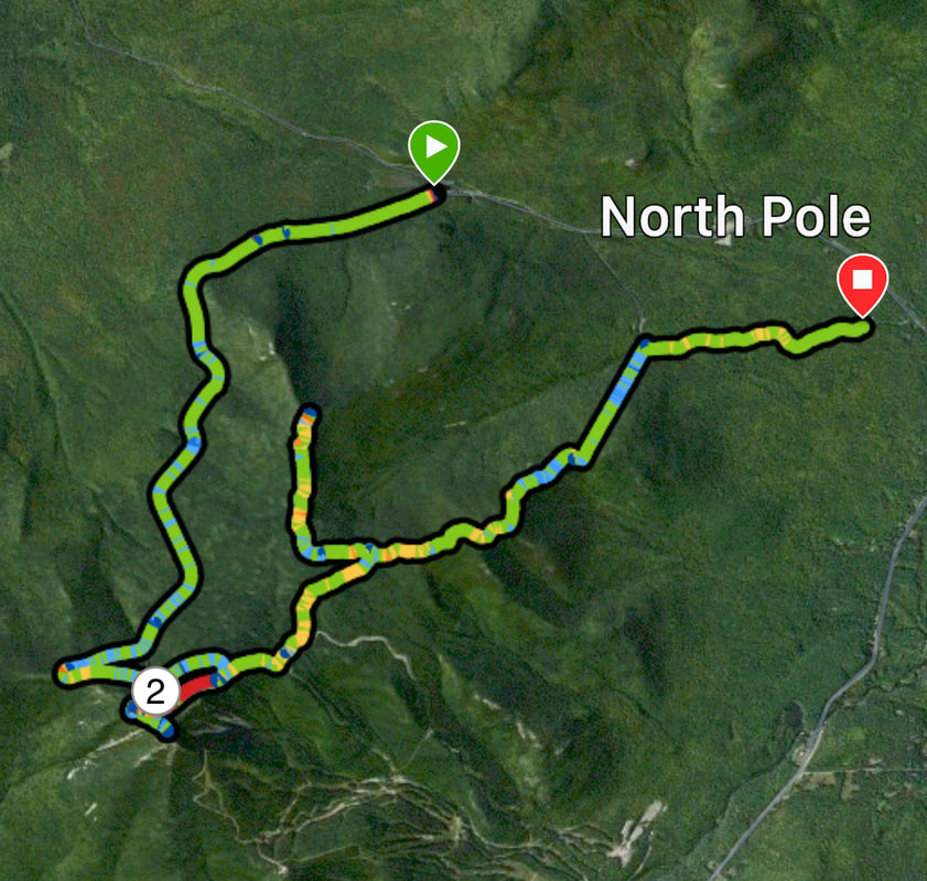
Our plan was to ski up the Toll Road as far as possible and bag Whiteface, and then ski back down the road to the hairpin turn where we would transition to snowshoes and hike downhill on the hiking trail to tag the summit of Esther and then ascend a short distance back up where we would transition back to skis and ski down the road back to the car. We left the toll road gate just after 8 AM on Monday March 13th in mild conditions. Luckily due to a healthy snow season, the toll road had full coverage from bottom to top. We skied up in backcountry nordic gear and fell into a steady rhythm and kept a comfortable aerobic pace so the conversation rolled as we ascended. Every thousand feet or so of elevation gain, we stopped to add more warmer layers: First a toque, then warmer mitts, then a shell jacket. The balmy spring like temperatures at lower elevation quickly disintegrated into full on winter conditions including snow fall, wind gusts, and in a cloud of grey! We were the only ones on the toll road that day and seemed to have the place to ourselves!
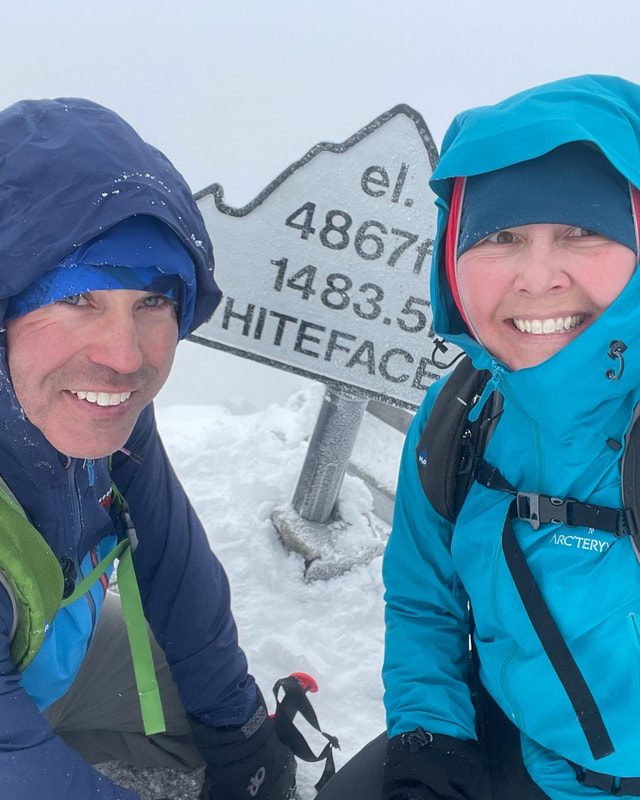
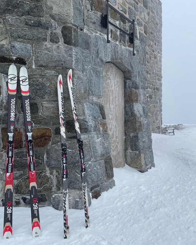
We reached the castle in 2.5 hours (2400' gain) where we took off our skis and threw on a pair of microspikes and headed up the last 200' of stairs and railings to the summit sign. The summit did not offer any stunning views on this day so we didn't linger. The summit at 4867 feet is exposed - and between the wind, cold, snow and clouds we took a few photos and scurried back down to our skis. We pulled off the microspikes and stepped into our skis and skied downhill through some wind scoured powder on the road and then picked up speed on a section of hard snow crust combined with some blinding upswelling wind gusts to the top of the first hairpin turn where the hiking trail and road meet. There is a small wooden post with a red trail marker here that indicates the merging of the road and hiking trail. Here Glenn mentioned to me that he had developed a blister on the back of his heel on the ascent. His ill fitting backcountry nordic boots had worn through the heel pocket and also worn the skin right off his heel. Even though I had blister bandages with me, I suggested that instead of snowshoe hiking down to bag summit #2, he just ski down the toll road back to the car in order to not make matters worse. We have been down this blister road before...
Our plan was to ski up the Toll Road as far as possible and bag Whiteface, and then ski back down the road to the hairpin turn where we would transition to snowshoes and hike downhill on the hiking trail to tag the summit of Esther and then ascend a short distance back up where we would transition back to skis and ski down the road back to the car. We left the toll road gate just after 8 AM on Monday March 13th in mild conditions. Luckily due to a healthy snow season, the toll road had full coverage from bottom to top. We skied up in backcountry nordic gear and fell into a steady rhythm and kept a comfortable aerobic pace so the conversation rolled as we ascended. Every thousand feet or so of elevation gain, we stopped to add more warmer layers: First a toque, then warmer mitts, then a shell jacket. The balmy spring like temperatures at lower elevation quickly disintegrated into full on winter conditions including snow fall, wind gusts, and in a cloud of grey! We were the only ones on the toll road that day and seemed to have the place to ourselves!
We reached the castle in 2.5 hours (2400' gain) where we took off our skis and threw on a pair of microspikes and headed up the last 200' of stairs and railings to the summit sign. The summit did not offer any stunning views on this day so we didn't linger. The summit at 4867 feet is exposed - and between the wind, cold, snow and clouds we took a few photos and scurried back down to our skis. We pulled off the microspikes and stepped into our skis and skied downhill through some wind scoured powder on the road and then picked up speed on a section of hard snow crust combined with some blinding upswelling wind gusts to the top of the first hairpin turn where the hiking trail and road meet. There is a small wooden post with a red trail marker here that indicates the merging of the road and hiking trail. Here Glenn mentioned to me that he had developed a blister on the back of his heel on the ascent. His ill fitting backcountry nordic boots had worn through the heel pocket and also worn the skin right off his heel. Even though I had blister bandages with me, I suggested that instead of snowshoe hiking down to bag summit #2, he just ski down the toll road back to the car in order to not make matters worse. We have been down this blister road before...
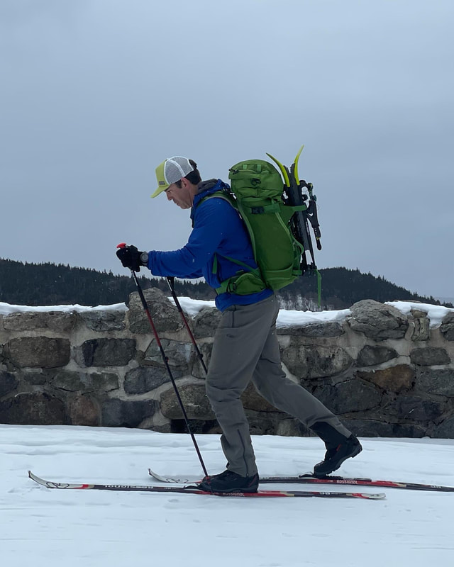
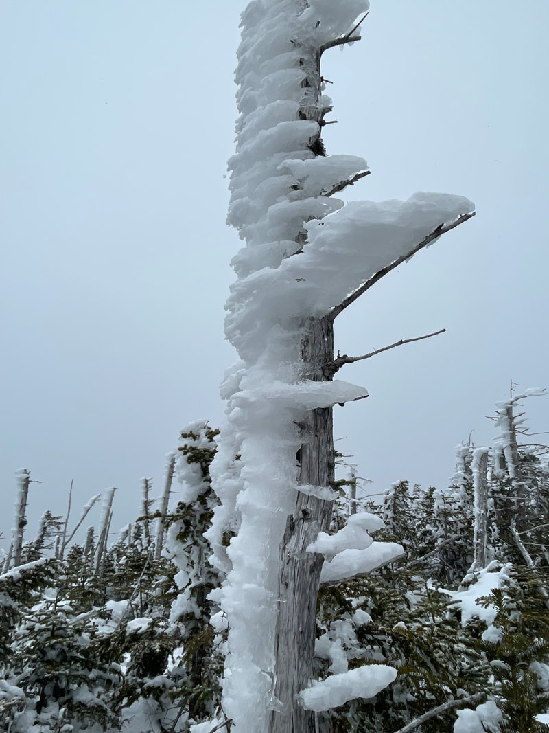
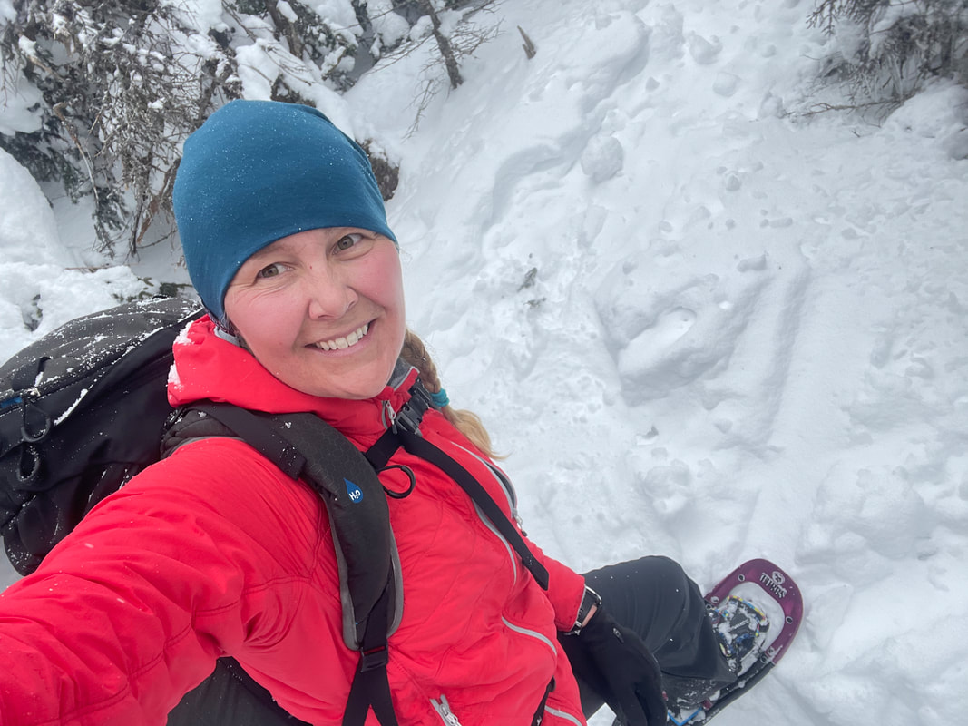
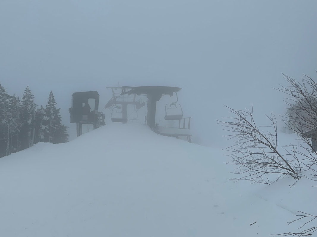
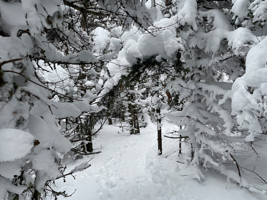
So we agreed that I would transition into snowshoes and hike down to the second summit of Esther while he would ski back to the car and meet me at the bottom of the hiking trail. I quickly threw on my winter hiking boots and snowshoes, packed up my ski boots into my pack, and grabbed some hot chocolate and snacks. My body temp was dropping and I needed to get out of the wind and get moving so off I went. I would have liked to have stayed to have gotten a photo of Glenn's descent set-up as he had a backpack on carrying not only his snowshoes but also my nordic skis A-framed on his pack! Alas, I was on a mission so I descended down the hiking trail at a feverish pace still with my battery operated mitts on and hood cinched in. 10 minutes into my hike I found myself looking at the top of a chairlift from the Whiteface Ski Resort which was barely noticeable in the cloudy conditions but could hear the strange hum of electricity not normally found in the woods! I crossed two ski runs and then kept my brisk pace on broken trail looking for the cairn and turn to Esther. I passed 3 young guys on rental snowshoes blaring their bluetooth speaker on their way up and a moment after I then took a sharp left at the herd path cairn. I took a moment to de-layer here as I was now 30 minutes into my hike and started to warm up. I wondered how Glenn was doing and if he was down to the car yet. I ascended over Lookout Mountain (there was no lookout views today) and kept up a brisk paced along the brushy herd path. I remembered how much I like solo hiking and being able to walk at your own pace. I ducked under a few fallen trees and felt a couple snow showers fall down the back of my neck. Along the way I encountered several trees with rime on them and spruce trees with icicles hanging down off them. I had forgotten to get the GPS from Glenn so I wasn't 100% sure I had reached the summit of Esther when the herd path ended but my Garmin watch was reading the right elevation at the time so I knew this had to be it. The summit marker for Esther is a plaque in a rock that was snow under several feet of snow that I couldn't see to confirm. I took a photo of me (with very red cheeks!) in the spot the plaque should be and checked my watch again. It took me 30 minutes to walk out to Esther from the marked trail and it had been 1 hour to get to Esther's summit from the toll road. I think my original plan would have worked well re-tracing my steps for the hour or so back and then skiing down the road. My estimate of 6-6.5hours would have been a pretty efficient plan!
Back on the summit of Esther, I had told Glenn I would send him an inReach message to him so he would know where I was at and how long it would take me. As Canadians in the US, we both don't have a US cell plan or opt for cellphone roaming charges but now that both of us have our own Garmin inReach communication devices, we can text back and forth and communicate via satellite. At my current pace, he was to pick me up at 2:30PM at the hiking trailhead. As I waited the minute for the inReach message to send, I chugged back another cup of hot chocolate and had another quick bite of food. Out of the wind, in the trees, and 600 feet lower than Whiteface, Esther's summit was a nice warm hug on a winter day. I re-traced my steps quickly on the beat down trail back to the marked trail. Snowshoes were definitely still needed even though the trail was broken. Winter hadn't given up it's fight yet! I started to descend down the marked trail through a few steeper areas keeping up a fast pace. At 3500', I got my first glimpse of the valley as I exited the cloud but the snowflakes kept pounded my face like they had for most of the day. I heard a beeping noise from my inReach - it was Glenn responding. He was back at the hotel and was coming to pick me up for 2:30pm. Technology works great sometimes! At the first junction at 2750', it was evident in winter that all of the traffic turns left towards the ARSC and Marble Mountain Road. The marked trail hadn't been used much at all and it didn't look like hiking traffic uses the marked trail to the reservoir parking at the bottom. The last time I had been to Whiteface and Esther in July of 2010, I we started at the bottom so that is where I told Glenn to pick me up. Not wanting to break a new trail for 3km, I turned left and descended a neverending well trod ramp down Marble Mountain. At the bottom were some green buildings and later found out there is a parking lot that hikers can use. I could have ended my hike here!
Instead I had to turn right on to a well-used snowmobile path backed to the marked trail and to the lower parking lot. The marked trail here did not look like it had been used by hikers much at all as there were many signs of bareboots, dog prints, and dog poop. Note to self: park at the Marble Mtn Road trailhead next time! I was slightly late for my pick up time due to the steep leg braking I had to repeatedly do on a 3000' decent. When I arrived at the parking lot Glenn and the care were there waiting for me. Glenn's descent on the toll road had been a mixed bag of hard and fast snow to some softer powder sections. He and his blistered heel did not regret his decision to ski down and I was able to get 2 more summits into my Winter 46 bag!
Unfortunately the weather deteriorated as a classic Nor'Easter parked itself over the High Peaks that same evening and shut the door on any more summits this trip. Next time!
Hike/Ski totals:
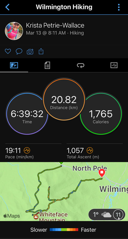
Distance: 20.82km
Time: 6hrs 39mins
Ascent: 1057m or 3467ft
Back on the summit of Esther, I had told Glenn I would send him an inReach message to him so he would know where I was at and how long it would take me. As Canadians in the US, we both don't have a US cell plan or opt for cellphone roaming charges but now that both of us have our own Garmin inReach communication devices, we can text back and forth and communicate via satellite. At my current pace, he was to pick me up at 2:30PM at the hiking trailhead. As I waited the minute for the inReach message to send, I chugged back another cup of hot chocolate and had another quick bite of food. Out of the wind, in the trees, and 600 feet lower than Whiteface, Esther's summit was a nice warm hug on a winter day. I re-traced my steps quickly on the beat down trail back to the marked trail. Snowshoes were definitely still needed even though the trail was broken. Winter hadn't given up it's fight yet! I started to descend down the marked trail through a few steeper areas keeping up a fast pace. At 3500', I got my first glimpse of the valley as I exited the cloud but the snowflakes kept pounded my face like they had for most of the day. I heard a beeping noise from my inReach - it was Glenn responding. He was back at the hotel and was coming to pick me up for 2:30pm. Technology works great sometimes! At the first junction at 2750', it was evident in winter that all of the traffic turns left towards the ARSC and Marble Mountain Road. The marked trail hadn't been used much at all and it didn't look like hiking traffic uses the marked trail to the reservoir parking at the bottom. The last time I had been to Whiteface and Esther in July of 2010, I we started at the bottom so that is where I told Glenn to pick me up. Not wanting to break a new trail for 3km, I turned left and descended a neverending well trod ramp down Marble Mountain. At the bottom were some green buildings and later found out there is a parking lot that hikers can use. I could have ended my hike here!
Instead I had to turn right on to a well-used snowmobile path backed to the marked trail and to the lower parking lot. The marked trail here did not look like it had been used by hikers much at all as there were many signs of bareboots, dog prints, and dog poop. Note to self: park at the Marble Mtn Road trailhead next time! I was slightly late for my pick up time due to the steep leg braking I had to repeatedly do on a 3000' decent. When I arrived at the parking lot Glenn and the care were there waiting for me. Glenn's descent on the toll road had been a mixed bag of hard and fast snow to some softer powder sections. He and his blistered heel did not regret his decision to ski down and I was able to get 2 more summits into my Winter 46 bag!
Unfortunately the weather deteriorated as a classic Nor'Easter parked itself over the High Peaks that same evening and shut the door on any more summits this trip. Next time!
Hike/Ski totals:
Distance: 20.82km
Time: 6hrs 39mins
Ascent: 1057m or 3467ft

 RSS Feed


